
Drone-captured. AI-mapped. Field-verified.
Drones capture the site, AI speeds up the mapping, and our crews check it on the ground, so we cover the whole map accurately, professionally and fast, with a written quote the same day.
Where we work
Enter your city as free text on the request form. If you are unsure whether a parcel is in the service area, include it anyway and we will confirm.
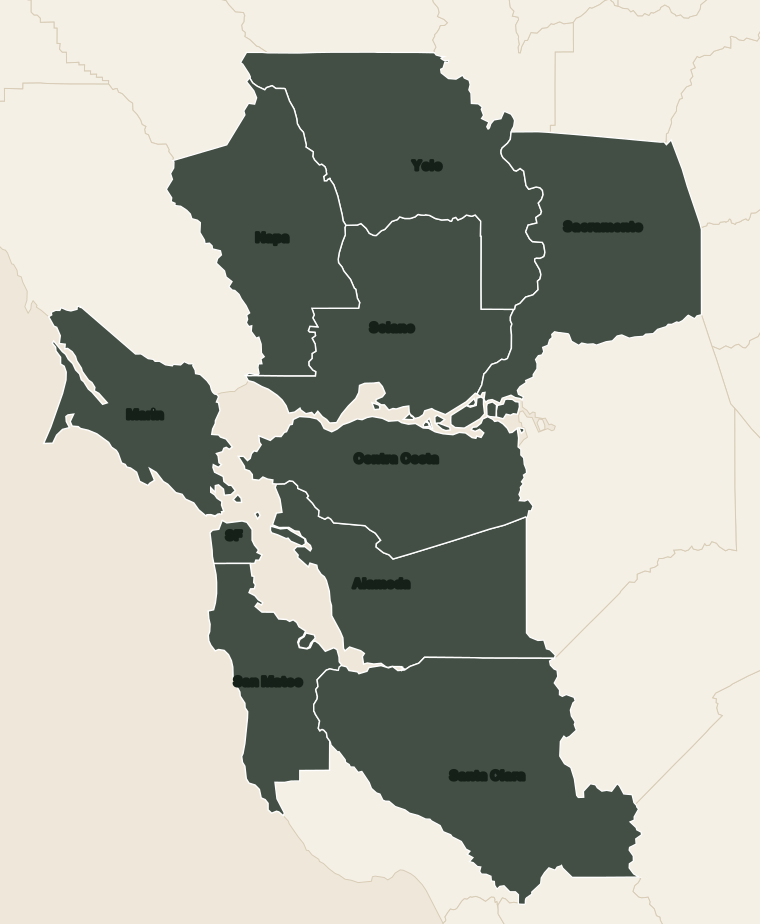
Shaded counties are in our service area. Santa Clara County coverage runs through Gilroy.
What we confirm before fieldwork
- County and parcel from the address and APN
- Records available for a same-day proposal
- Access notes that affect a later field date
- No field date is promised before that review
City pages
Written pages for cities we have described in more detail. Other cities on the map are still in our service area.
San Jose
Fences, ADUs, and SB 9.
San Francisco
ADU and tight-lot surveys.
Oakland
Property lines.
Palo Alto & Menlo Park
Additions and ADUs.
Fremont & the Tri-Valley
Fremont, Pleasanton, Livermore, Dublin.
Walnut Creek & Concord
Contra Costa fences and ADUs.
San Mateo & Burlingame
Peninsula boundary work.
Berkeley & Albany
Hills and small lots.
Gilroy & Morgan Hill
Why we stop at Gilroy.
Sacramento
Central city lots and later tracts.
Elk Grove
Tract homes and fence lines.
Folsom
Hillside and river-adjacent parcels.
Davis
In-town lots and ADU site work.
Woodland
Downtown grid and larger edge lots.